Archive Record
Images
Metadata
Catalog Number |
1998-124-146 |
Accession number |
1998-124 |
Object Name |
Map |
Collection |
Ralph Rambo Collection |
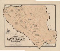
Title |
Map of Santa Clara Co. Ranchos : A delineation of Spanish-Mexican Government Land Grants or Ranchos and Pueblo Sites in Early Santa Clara Valley (A Few Well Known Later-Day Landmarks Were Added to Orient the Reader) |
Date |
1968/ / |
Dates of Creation |
1968 |
Year Range from |
1968 |
Year Range to |
1968 |
Description |
Map of Santa Clara County Ranchos, created by Clyde Arbuckle and Ralph Rambo in 1968 based on maps from the 1860s-1890s. Historian: Clyde Arbuckle Artographer: Ralph Rambo Sources: Thompson & West's Atlas of Santa Clara County - 1876; Map of the Pueblo Lands of San Jose - Thompson Survey 1866 (From Hall's History of San Jose); U.S. Geog. Survey - San Jose Quadrangle - 1895 - R. B. Marshall; Map of Bay Region - State Geog. Survey - C. F. Hoffman - 1873; AAA Map of Santa Clara Valley (Modern) |
Creator |
Rambo, F. Ralph |
Other Creators |
Arbuckle, Clyde |
Level of description |
Item |
Subjects |
Maps Land grants Santa Clara County (Calif.) Nineteenth century (LCSH) Spaniards Mexicans |
Relation |
Show Related Records... |
High Resolution Original Image |
View online (Internet Archive) |
Donor |
Gift of Ralph Rambo |